


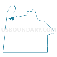
Sunray I Voting District, Chesapeake city, Virginia
About
Outline

Summary
| Unique Area Identifier | 682776 |
| Name | Sunray I Voting District |
| County | Chesapeake city |
| State | Virginia |
| Area (square miles) | 1.68 |
| Land Area (square miles) | 1.68 |
| Water Area (square miles) | 0.00 |
| % of Land Area | 100.00 |
| % of Water Area | 0.00 |
| Latitude of the Internal Point | 36.77558220 |
| Longtitude of the Internal Point | -76.41794850 |
Maps

Graphs
Select a template below for downloading or customizing gragh for Sunray I Voting District, Chesapeake city, Virginia


Neighbors
Neighoring Voting District (by Name) Neighboring Voting District on the Map
- John F. Kennedy Voting District, Suffolk city, VA
- Jolliff One Voting District, Chesapeake city, VA
- Nansemond River Voting District, Suffolk city, VA
- Sunray Ii Voting District, Chesapeake city, VA
Top 10 Neighboring County Subdivision (by Population) Neighboring County Subdivision on the Map
Top 10 Neighboring Place (by Population) Neighboring Place on the Map
Top 10 Neighboring Unified School District (by Population) Neighboring Unified School District on the Map
Top 10 Neighboring State Legislative District Lower Chamber (by Population) Neighboring State Legislative District Lower Chamber on the Map
Top 10 Neighboring State Legislative District Upper Chamber (by Population) Neighboring State Legislative District Upper Chamber on the Map
Top 10 Neighboring 111th Congressional District (by Population) Neighboring 111th Congressional District on the Map
Top 10 Neighboring Census Tract (by Population) Neighboring Census Tract on the Map
- Census Tract 215.01, Chesapeake city, VA (10,150)
- Census Tract 214.04, Chesapeake city, VA (7,671)
- Census Tract 213.01, Chesapeake city, VA (5,396)
- Census Tract 755.01, Suffolk city, VA (4,711)
- Census Tract 755.02, Suffolk city, VA (4,002)